Category Archives: City rediscovers walking

CARSON CITY TAKES BACK The MaIN STREET

22552958_1677729645572537_1326480646615013031_o.jpg

Taking Back the Main Street-The Carson City Story

Carson City Nevada has achieved a remarkable initiative with their main street. This is an unheralded story of how a small city went about  reclaiming their historic downtown back from thoroughfare highway use to more pedestrian friendly sidewalks, bike lanes, and slower vehicular flows to bring back walking and cycling locals.

Carson City Nevada is 30 miles south of Reno with a population of 58,993 (2021) and is also the state capitol of Nevada. The downtown contained a lot of important heritage buildings as well as the landscaped grounds for the state capitol, but crossing the main road was dangerous.

Four lanes of vehicle drivers went through Carson Street at speed, and pedestrians were hurt and killed trying to cross the street. At one point the City installed fence barriers along the narrow sidewalk to try to separate pedestrians from vehicles, which did not reduce the crashes and serious injuries. It did not make for an inviting experience on this main commercial street.

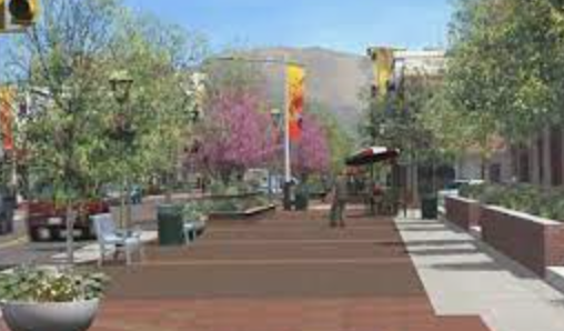
With the use of a .08 per cent  local sales tax, the City was able to issue bonds to pay for a revamping of their downtown corridor. Utilities were replaced under the road surface, and the street made more walkable and visually interesting by the use of  new wide non glare sidewalks, plantings, dropped curbs, pedestrian activated crossings, bike lanes, and attention to detail in textures and materials. That four lane highway was throttled down to one lane in each direction, with a bike lane on either side of the street.

22406444_10212421879055291_5271322934965050929_n

First opened in the Fall of 2016, you can continually visit Carson City (and yes, it is called Carson Street) to see how the street is functioning, and whether the improvements are a success.

The late Mayor Bob Crowell noted that there had been no pedestrian accidents on the street since the new street treatment had been installed. The new street is designed to maintain cars travelling at the posted speed and no faster. There are quick button activation pedestrian crossings throughout the downtown. The design and development of a plaza on a previously opened street has a stage and a kid friendly splash pad, and has small local businesses and outside seating areas for people to linger.

22449988_1611348775577032_8524299812076313740_n


But most importantly,  “early adapter” businesses that focus on all segments of the local population have opened, most notably “Scoups Ice Cream and Soup Bar with engaging staff, a plethora of ice cream flavours, and a ready-made place for kids of all ages to hangout and reflect in the adjoining plaza. As several teenagers admitted, there was no reason to come to the main street of Carson City before, as there was nothing of interest. Now with an  ice cream and soup bar and open seating outside the store, teenagers feel comfortable and have a sense of belonging in the plaza as do seniors and families.

That is what successful placemaking is all about.

IMG_2305
IMG_2301
IMG_5518

It is no surprise that many locals now are using the downtown Carson Street in a different way, as a place to walk to and to linger. As well new eateries have opened, including The Great Basin Brewing Company which is always busy and attracts hungry visitors from Reno.

Carson City now has a “there there” in the downtown, and is experiencing a renewed interest in its downtown commercial area. The city has a strong arts focus and now has a downtown that is accessible and attractive to pedestrian and bicycle users. Buildings along Carson Street are being renovated, and a new mixed use building with rental apartments on the top floor is being built on a sidestreet. Carson City’s decision to throttle four lanes of through traffic and enhance walking and cycling facilities has enhanced local shopping by bike and by foot is already reaping returns.

IMG_2291
IMG_2339
IMG_2321
22405521_1611345052244071_400518240779704761_n


images: CarsonNow, sandyjames

Does Your Public Space Pass the Seven Year Test?

Does your Public Space Pass the Seven Year Test?

It was Chris Foxon, a former groundskeeper for the Vancouver School Board that noted that publics change, and that in every seven years there was a new cohort of people that are using public spaces. Mr. Foxon saw the effective use of space as having a seven year life span before those space need to be re-evaluated or repurposed for changing people and interests.

The Tupper Neighbourhood Greenway has been one of the city’s most constant and neighbourhood loved spaces located to the north of Tupper Secondary School in the 400 block of East 23rd Avenue.

The street on this block had been originally closed in the 1970’s due to street racing, and had been left as a closed asphalt surface with two chains on either street end. One side was playing fields associated with the school; the other side was the physical campus of the school. That closed street stayed that way for over thirty years.

In 2003 a student at Tupper Secondary, Jomar Lanot went to play basketball with friends on the school grounds on a weekend. Leaving the grounds he was accosted by a gang not related to the school. He was murdered.

In the aftermath of this tragedy the neighbourhood wanted to do something to commemorate this tragedy, and  to bring the community together after such a horrendous event. Walking with community members and teachers, formalizing this closed street into a public space that could be used by residents and the school seemed like the right thing to do.

You can look at the report to Council on this neighbourhood greenway here.

The design for this closed street was developed in concert with school students, who actually led some of the public process. The city’s engineer on the project, Linda Chow, had been a graduate of Tupper Secondary. Over several months the design was collaborated upon, and featured two infiltration gardens at each end of the street, a small amphitheatre of boulders for class teaching and a commemorative boulder in the centre.

The benches that are surrounding the boulder were designed by the shop class at the school, and were fabricated there.

In the City of Vancouver you cannot commemorate people on city streets, so Jomar’s name could not be put on the rock. But what could be placed was a quote. The school student body was given a choice of several quotes that could be engraved on the rock, and they chose a quote which came from Jomar’s school notebooks:

Culture is the root of our lives and Love is the most powerful force”.

The engraving on the rock was done onsite so that the students could witness that  part of the process.
When this neighbourhood greenway was planted, the school and community came out to do the work, while the culinary program at the school provided the cuisine. The VanDusen Master Gardeners followed up doing garden replanting, weeding and maintenance and had an active committee that stewarded the garden. The Lanot family was involved in the planting and the maintenance of the space, and Jomar’s mother spoke at the opening of the greenway.

The students at Tupper Secondary won the Mayor’s Award for Youth Involvement for their participation in the project in 2008.

This is a space that is always used. There is a violincello player that comes in the early afternoons to practice. Children and adults use the space, and there is a bikeway path that goes through the space. The garden portions of the greenway are well maintained and cared for.

These photos show how the gardens look today, with some maintenance being done on the infiltration gardens. The concept and space are now approaching 14 years of being actively used and maintained, although the original story of who Jomar was and how he died has been lost to many newcomers in the area. But the intent of the space, to bring community together carries on.

It is one of the most successful ongoing community spaces in east Vancouver, and illustrates the power of legacy when it is the right idea at the right time: inclusive open space for both students and residents.

Want to Boost Retail Sales? Add in Walking and Cycling Facilities

pedestrians

Of course it makes intuitive sense that active transportation users and bus commuters would frequent retail businesses more often than those constrained by  vehicles. But it is always better to have the hard facts on this data, and researchers in the City of London England have done just that.

Transport for London (TfL)  in Great Britain has released a new study  with some staggering statistics about what happens when street improvements are made to facilitate walking and cycling. Time spent on retail streets increased by 216% between shopping, patronizing local cafes and sitting on street benches. Retail space vacancies declined by 17%.  London’s Business Improvement Districts are 90% in favour of more street improvements to facilitate pedestrians, and 85% in favour of better facilities for cyclists.

But the best news, and this is also in line with research conducted in Toronto and in New York City “people walking, cycling and using public transport spend the most in their local shops, spending 40% more each month than car drivers”.

The study for TfL was conducted by a researcher at University College London’s Bartlett School of Planning. Footfall and retail sales in unimproved areas were compared to shopping areas that had implemented improvements such as wider sidewalks, increased outdoor seating, public parks and pedestrian crossings.  Findings showed that retail rents  increased by 7% in improved areas, and office space rents increased by 4%, suggesting that the street improvements translated into much more desirable spaces. You can download the entire report, which also has some great business case references for retail areas  here.

Local business improvement districts in London are also understanding the benefits of increased pedestrian and cycling clientele, with 90% seeing the advantages of pedestrian improvements and 85% wanting more cycling facilities in their area.

Will Norman, London’s Walking and Cycling Commissioner, said: ‘With businesses across London really struggling to survive, we have to do everything we can to support them.‘The evidence is clear – adapting our streets to enable more people to walk and cycle makes them cleaner, healthier and more welcoming, which encourages more people to shop locally.‘The benefits of designing streets around pedestrians and cyclists and reducing car use can be enjoyed by everyone and will help ensure the future of our high streets.’

And of course, more pedestrians and more cyclists on separated facilities, improved street design and slower speeds make roads safer and encourage travel to retail businesses by active transport, and make retailers more money.  This BBC video below talks about Vision Zero and how to make the streets of London safer for everyone.

The Walkable Block & the Legacy of Vancouver’s Davis Family

John Davis Jr. with Pat Davis

It seems only fitting in the month with “British Columbia Day” in this province that we celebrate the remarkable Davis family and Pat Davis who passed away last week.  This family made their street a walkable wonder.

Over a period of five decades the Davis Family stewarded a group of Edwardian and Victorian  houses on Mount Pleasant’s  100 block of West Tenth Avenue just east of city hall, restoring them. At the time in the late 70’s and early 80’s renovating old houses and fitting them with rental units was not the thing to do. The Davis family fought pressure to turn their houses into a cash crop of three-story walk-ups  on their street, and proudly display a plaque indicating that their restoration work was done with no governmental assistance of any kind.

But more than maintaining a group of heritage houses that described the rhythm and feel of an earlier Vancouver,  the Davis family extended their interest and stewardship to the street. In the summer a painted bicycle leans on a tree near the sidewalk with the bicycle basket full of flowers~in season there is a wheelbarrow to delight passersby full of  blooming plants. An adirondack chair perches near the sidewalk. And every morning, one of the Davis family was out sweeping the sidewalk and ensuring that no garbage was on the boulevards or the street.

As author and artist Michael Kluckner notes the Davis Family’s stewardship profoundly altered the way city planning was managed in Mount Pleasant. As one of the oldest areas of the city with existing Victorian houses, zoning was developed to maintain the exterior form and add rental units within the form. The first laneway houses in the city, called “carriage houses” were designed for laneway access and to increase density on the lots. And when it came time for a transportation management plan, residents threw out the City engineer’s recommendations and designed their own. That plan is still being used today.

John Davis Senior passed away in the 1980’s but his wife Pat and his sons John and Geoff maintained the houses and managed the rentals. Michael Kluckner in an earlier Price Tags post described the Davis Family as being strongly in the tradition of social and community common sense.

They championed street lighting for Tenth Avenue, with the street’s residents  choosing (and partially paying for) a heritage type of lighting standard. The City’s engineer at the time thought that the residents of Tenth Avenue would never pick a light standard that they would have to pay for . The City’s engineer was wrong.

Pat Davis also single handedly changed the way that street trees were trimmed by B.C. Hydro. When I was working in the planning department I received a call from B.C. Hydro indicating that trimming work on the Tenth Avenue large street trees had to be halted due an intervention from Mrs. Pat Davis. Pat was horrified that hydro crews were cutting back street trees down to their joins (called “crotch dropping”) to ensure that hydro wiring was not compromised. A spritely senior, Pat Davis had taken the car keys away from  B.C. Hydro personnel  and refused to give them back until the hydro crew agreed to leave.

A subsequent report to Council led to B.C. Hydro agreeing to raise the electrical wires passing through the street trees, so that the trees could maintain their natural form. That is now city policy.

You can read more about the Davis family and the Tenth Avenue houses in this article by CBC’s Rafferty Baker. You can also read Pat Davis’ obituary here.  The Davis family demonstrates the “varied talent” of good community that Jane Jacobs passionately describes.  Pat Davis and her stewardship will be greatly missed.

Vancouver’s Robson Square, and why it was always supposed to be Walkable

van-shake-0512

Vancouver Sun’s Dan Fumano talks about an interesting perception with the work of the current Vancouver City Council.  Dan was referring to  the council report on the “court house block” of  800 block of Robson Street and the potential decision to approve over five million dollars to create a permanent plaza at this location. You can read the report to Council on this here.

This has been a long talked about initiative and even the architect for the Robson Square court house Arthur Erickson had discussed the closure of this portion of street in the 1970’s. It is not a new idea and it is not something that the previous Vision party  dominated city council dreamed up.  But somehow in the last decade there is a sea change in the way that Vancouverites perceive that work initiated by the City is the “vision” of the ruling party, and not the result of careful reasoned work undertaken over the years by  city staff, who also embark upon extensive public processes to review and comment upon potential plans and projects.

The last Vision party dominated Council contributed to the perception of council as project mavericks by having Council members talk about projects instead of having experienced City staff explain elements of the projects they would have painstaking detail and knowledge of.

While this may have been a well-meaning strategy to give Councillors more media time, it also contributed to a growing distance between policy and the staff people who were actually working on and charged with implementing the policy. The street closure of the court-house block is a prime example of something that was done to connect the street for pedestrians and cyclists, and was a policy direction, not a political council initiative.

As Dan Fumano observes, the pedestrianization of the Granville Bridge and the extension of the subway along Broadway are not creations of the previous Vision council, but were outstanding work objectives from city staff acting upon previously approved city policy.

Back to the closure of the Robson Square block of 800 Robson Street. You can see a  video of broadcaster Jack Webster touring through the Robson Square  park in 1978 when the court house’s public spaces were first opened to the public. Mr. Webster mentions that the old court house was sold to the City “for a dollar” and  still needed renovation to become a gallery. But in the images you can also see how the street functions as a mall connecting space between the old and the new court houses, and how it lends itself to be rethought as a public space for people not  for vehicles. The architect’s intent was that the entire three block area including the 800 block  Robson Street portion be closed to traffic. That was architect Arthur Erickson’s vision four decades ago, and a direction that has been explored by city staff over the years.


Giving Pedestrians the “Green Man” Priority in London

tfl-diversity-lights-2

As part of Mayor Kahn’s plan to increase daily walking trips in London from 6 million to 7 million by 2041,  the City of London is looking at how to make walking safer, comfortable and more convenient for walkers.  While adjusting signals to give pedestrian more “green man” time at signalized intersections,  staff will also be using “SCOOT”.

SCOOT stands  for “Split Cycle Offset Optimization Technique” which will be installed at ten intersections to give pedestrians priority. The city of London is on a mission to make walking as convenient as possible, using smarter traffic signals that reduce wait times for pedestrians. These smart signals ” can detect the number of pedestrians waiting at an intersection and automatically adjust timing to minimize their wait and ensure they have enough time to cross” according to Streetsblog.

And here’s the cool part~the “Green Man” initiative allows for a continuous pedestrian green signal until vehicular traffic is near, when pedestrians are then given the red signal. The technology has been tested by Transport for London on two streets with only bus traffic prior to this wider rollout, and was very well received by pedestrians. This is all part of the London Walking Action plan which can be viewed here.

crossing_2209318k

Designing for Pedestrians and Cyclists Boon for London Retail Businesses

Of course it makes intuitive sense that active transportation users and bus commuters would frequent retail businesses more often than those constrained by  vehicles. But it is always better to have the hard facts on this data, and researchers in the City of London England have done just that.

Transport for London (TfL)  in Great Britain has released a new study  with some staggering statistics about what happens when street improvements are made to facilitate walking and cycling. Time spent on retail streets increased by 216% between shopping, patronizing local cafes and sitting on street benches. Retail space vacancies declined by 17%.  London’s Business Improvement Districts are 90% in favour of more street improvements to facilitate pedestrians, and 85% in favour of better facilities for cyclists.

But the best news, and this is also in line with research conducted in Toronto and in New York City “people walking, cycling and using public transport spend the most in their local shops, spending 40% more each month than car drivers”.

The study for TfL was conducted by a researcher at University College London’s Bartlett School of Planning. Footfall and retail sales in unimproved areas were compared to shopping areas that had implemented improvements such as wider sidewalks, increased outdoor seating, public parks and pedestrian crossings.  Findings showed that retail rents  increased by 7% in improved areas, and office space rents increased by 4%, suggesting that the street improvements translated into much more desirable spaces. You can download the entire report, which also has some great business case references for retail areas  here.

Local business improvement districts in London are also understanding the benefits of increased pedestrian and cycling clientele, with 90% seeing the advantages of pedestrian improvements and 85% wanting more cycling facilities in their area.

Will Norman, London’s Walking and Cycling Commissioner, said: ‘With businesses across London really struggling to survive, we have to do everything we can to support them.‘The evidence is clear – adapting our streets to enable more people to walk and cycle makes them cleaner, healthier and more welcoming, which encourages more people to shop locally.‘The benefits of designing streets around pedestrians and cyclists and reducing car use can be enjoyed by everyone and will help ensure the future of our high streets.’

And of course, more pedestrians and more cyclists on separated facilities, improved street design and slower speeds make roads safer and encourage travel to retail businesses by active transport, and make retailers more money.  This BBC video below has been just released talking about Vision Zero and how to make the streets of London safer for everyone.


Is New York City’s Times Square the Walkability Blueprint for Other Cities?

IMG_0737

What used to be a very seedy, dirty and crowded area of New York City has undertaken a dramatic renewal as a place for people to linger, chat, and just hang out. Even though the land on Broadway between 42nd and 47th Streets is less than .01 per cent of the actual surface of New York City, it is responsible for 11 per cent of the city’s economic output.
With 330,00 people visiting daily, Times Square has a mix of about 56 per cent locals to 44 per cent of tourists. Through Janette Sadik-Khan’s championing of Times Square as a people not a vehicle place, there has been a remaking of this place by simply making it more and more pedestrian friendly.

IMG_0373

Walk Metro Vancouver was in New York City in May 2009 when Broadway Avenue was being closed down for traffic, and the NYC Department of Transportation and the  Department of Design and Construction got rid of the old foggy stuff in the square and brought in streamlined fifty foot long granite benches. The transformation was immediate. People sat down on what ever seating device was available, including the green stamped concrete.

As reported in Mic.com, the architecture and landscape firm Snohetta led the process to design the new plaza, including the public and city officials in the discussions.Curbs were eliminated, the “temporary” pedestrian plazas were made permanent. Over twenty agencies and public interest groups had previously been involved in plans to change this area ,with none successful. So what made the difference?
Craig Dykers, the founding partner of Snohetta observes:  “For half a century, numerous plans for Times Square had been proposed by designers to help Times Square meet its changing needs and manage pedestrian and vehicular congestion. None of these plans found traction or were approved.” But by recognizing that 300,000 people a day travel by foot through the area and making those pedestrians~and their interaction with the space~ a priority, this has been a great success.  With the project officially completed in 2016, “There’s been a 20% decrease in crime, a 40% decrease in pedestrian injuries and a 60% decrease in pollution.” 

Eighty per cent of users say the space feels safer, and 93 per cent say it’s a more pleasant place. “Cities need to be smart,” Craig Dykers stated. “It is critical now more than ever to evaluate how much space is needed for cars and traffic and ask if there is space that would be better tailored to pedestrian use.“In each case, we must ask: Does removing the street provide value for users as well as adjacent businesses? How can we continue to cultivate open, vibrant and unique public spaces that increase public safety and promote diverse ways of thinking? These are questions that are being asked with greater urgency, especially as issues of pedestrian safety and secure public space are more pressing than ever.”

IMG_0378

Carson City Nevada Steps Up to a Walkable Downtown

22552958_1677729645572537_1326480646615013031_o.jpg


Walk Metro Vancouver has reported on a phenomenon that is occurring in many towns that are reclaiming their historic downtowns back from thoroughfare highway use to more pedestrian friendly sidewalks, bike lanes, and slower vehicular flows more attractive for locals.

Carson City Nevada is 30 miles south of Reno, has a population of 55,300 (2010) and is also the state capitol of Nevada. Despite a downtown that contained a lot of important heritage buildings as well as the grounds for the state capitol, motordom reigned supreme on the main street. Four lanes of traffic went through Carson Street at speed, and pedestrians were hurt and killed trying to cross the street. At one point the City installed fence barriers along the narrow sidewalk to try to separate pedestrians from vehicles. It did not make for an inviting experience on this main commercial street.

With the use of a 1/8 per cent  local sales tax, the City was able to issue bonds to pay for a revamping of their downtown corridor. Utilities were replaced under the road surface, and the street made more walkable and visually interesting by the use of  new wide non glare sidewalks, plantings, dropped curbs, pedestrian activated crossings, bike lanes, and attention to detail in textures and materials.

22406444_10212421879055291_5271322934965050929_n

Opened in the Fall of 2016, Walk Metro Vancouver visited the street  to see how the street was functioning, and whether the improvements were a success. Mayor Bob Crowell noted that there had been no pedestrian accidents on the street since the new street treatment had been installed. The new street is designed to maintain cars travelling at the posted speed and no faster. There are quick activation pedestrian crossings throughout the downtown. The design and development of a plaza on a previously opened street has a stage and a kid friendly splash pad, and has small local businesses and outside seating areas for people to linger.

22449988_1611348775577032_8524299812076313740_n

But most importantly,  “early adapter” businesses that focus on all segments of the local population have opened, most notably “Scoups Ice Cream and Soup Bar with engaging staff, a plethora of ice cream flavours, and a ready-made place for kids of all ages to hangout and reflect in the adjoining plaza. As several teenagers admitted, there was no reason to come to the main street of Carson City before, as there was nothing of interest. Now with an  ice cream and soup bar and open seating outside the store, teenagers feel comfortable and have a sense of belonging in the plaza. That is what successful placemaking is all about.


It is no surprise that many locals now are using the downtown Carson Street in a different way, as a place to walk to and to linger. As well new eateries have opened, including The Union which is always busy and attracts hungry visitors from Reno.
Carson City now has a “there there” in their downtown, and is experiencing a renewed interest in its downtown commercial area. The city has a strong arts focus and now has a downtown that is accessible and attractive to pedestrian and bicycle users. Buildings along Carson Street are being renovated, and a new mixed use building with rental apartments on the top floor is being built on a sidestreet. Carson City’s decision to shelve motordom and to enhance local shopping by bike and by foot is already reaping early returns.


 22405521_1611345052244071_400518240779704761_n

Why Can’t We Build “Great Streets” for Pedestrians?

140905-pico-sitevisit2287229


There is a shift in the conversation about the rights of pedestrians and cyclists to travel comfortably, conveniently and safely on Metro Vancouver streets. This discussion has been highlighted internationally in the media and you can take a look at almost any historic street photo from the early 20th century and see a surprising truth~in the early 1900’s pedestrians and bikes mingled and crossed streets, with vehicles either interspersed or travelling a slow enough speed to allow for such passage.


view-of-the-400-block-granville-street-from-west-hastings-street


While in the early 20th century cities and streets were still being designed as if pedestrians and not cars shopped there, streets then morphed into emphasizing automobile movement and motordom efficiency. Getting places faster was always  from a vehicle driver’s perspective, not that of pedestrian.


The Toronto Star’s Christopher Hume describes it this way: Streets have also become the forgotten element in our efforts to create a livable city. In Toronto, the focus is on parks, housing, towers and transit; streets are left to fend for themselves. At the same time, however, streets are under more pressure than ever as the historic dominance of the car is challenged by other groups, namely cyclists and pedestrians. The car has wreaked untold damage on our streets as well as our cities. Its needs are at odds with those of the urban environment. Cars are quick. Cities are slow. Cars want highways, fast roads that run as straight as possible with as few interruptions as possible. City roads, by contrast, must accommodate not just vehicular traffic but the activity that unfolds along its edges, the shops, restaurants, museums, malls, schools, cafes, courts . . .


Hume also notes that there are no “Great Streets” in newer towns and cities. The art of street building has been lost in the bid to champion accessibility of the car.  Matthew Fleischer of the Los Angeles Times notes that in Los Angeles pedestrian collisions have doubled in two years with a 58 per cent increase of fatalities. Efforts to slow traffic down, change design and driver behaviour have resulted in “political backlash” to City Council whenever pedestrian safety is improved. As Fleischer observes “the rising body count seems to indicate that pedestrian safety falls somewhere between tree trimming and gum removal on their priorities list.”

Economic studies clearly show that designing streets for walkers and bikers increases the retail success of  businesses on commercial streets. Instead of looking at walking, biking and vehicular traffic as pieces that need to be protected from each other, more integrated approaches are needed to holistically design for all modes, to get back to the early 20th century concept of street. One of the most important urban design elements in the 21st century will be the design of streets that capture the sociability, health, and connectivity of streets from a pedestrian and cyclist perspective. Allan Jacobs started this conversation in his book Great Streets looking at the components that made these streets successful, welcoming, and sticky for pedestrians. Wresting control of our own great streets  from motordom will be this century’s challenge.


granville-street-looking-north-from-about-dunsmuir-street-1900-city-of-vancouver-archives