Category Archives: Uncategorized

Artist Sarah Ross Addresses “Hostile Architecture”

Featured image for “Not Brutal But Hostile: Artist Sarah Ross Addresses Hostile Architecture”

December 15, 2022

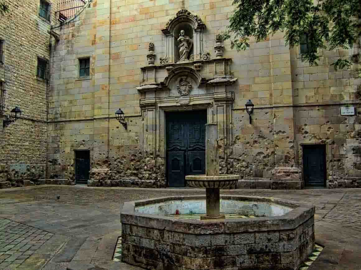
Brutalism or Brutalist design came out in the mid 20th century as a blocky concrete style with lots and lots of concrete. Everything was overscale, and usually in cold looking geometric patterns. Buildings designed in this style did not have much to offer on the ground plane, which was normally just as desolate an area as the facade of these buildings.

A good Vancouver example is the medical/dental building at 805 Broadway designed by architect Vlad Plavsic. It has great views from the upper floors. And a whole lot of concrete on the interior and the exterior.

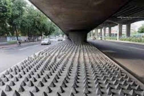
There is another name for the fostering of exterior environments in cities that are just not that welcoming to people, and try to minimize opportunities for people to sit, sleep, or stay around. That moniker is “hostile architecture” and we have all seen it-from rounded corners on buildings to discourage people urinating, to benches that are designed for one person to sit on.

Chicago based artist Sarah Ross created “archisuits” over 15 years ago to address the hostile design of public spaces and buildings, and her work is still elemental post pandemic.

As described by Grace Ebert in Colossal,  “Ross’s four leisurewear pieces bulge with supports that perfectly fit into the negative space of benches, fences, and building facades. The designs draw a contrast between the soft, bendable wearables and the cold, rigid architecture, which the artist describes as “an arm of the law, a form that uses the built environment to police and control raced, classed, and gendered bodies.”

Ms. Ross has designed four suits that work perfectly on environments where people are not supposed to recline, sit, or lean on. Her statement about hostile design is just as true today. You can find out more about Ms. Ross’s work on her website here.

images:sarahross,rft

The Importance of Tenji Tactile Blocks

4608876030_423x286

Do you know who Seiichi Miyake is? With many thanks to City of North Vancouver councillor Tony Valente for passing this #Googledoodle along about Mr. Miyake and the incredible contribution he made for sight impaired people.

In 1965 Mr. Miyake who is an engineer developed “Tenji” or tactile blocks to warn vision impaired people where to stand when trying to board trains. His invention has been adopted globally and is part of the sidewalk and public realm in many countries. As well theTenji blocks are known as “truncated domes”, “tactile warning surfaces”, “detectable warning tiles”  and “tactile pavement.” 

They all describe the same invention which are a “signal to stop or go” writes Jessica McBride at  Heavy.com. The first installation was on this day in  Japan in 1967 on a street near the Okayama School for the Blind. Japan embraced the tactile blocks at all railway stations within a few years of the development of the blocks.

Since 80 percent of sight impaired people have some vision, the blocks can also guide as they are a different colour from the surrounding pavement surfaces.

The YouTube video below provides a brief history on Mr. Miyake’s invention and also explores its application globally.

https://www.youtube.com/watch?v=x1PEiOJzi3E&feature=youtu.be

Data Says Building Walkability Saves Lives

IMG_6813-1485243689-1553153573714.jpg

There’s more evidence about the importance of creating walkable communities in a new study that was reported in The British Medical Journal. While cities strive to have goals such as bus stops within a ten minute walk of every residence, research undertaken by Dr. Bo Xi, at Shandong University’s School of Public Health illustrates that walking to the stop may actually be extending transit passengers’ lives.

Inverse.com writes that  researchers found that walking, dancing or even gardening for “10 minutes to an hour per week was associated with an 18-percent lower risk of death compared to people who did nothing.”

It is no surprise that people who did even more gentle exercise like walking half an hour a day or 150 minutes a week as a minimum had a 34 percent lower death risk. And there was good news for seniors aging in place in their communities~strokes and heart attack risk fell  by 12 percent with moderate exercise.

Sampling data came from the annual National Health Interview Surveys in the United States. Looking at figures for the years from 1997 to 2008, the amount of activity of over 80,000 people was estimated, and then linked to registered death data up to the end of 2011. The researchers used figures collected through the surveys between 1997 and 2008 to estimate the activity levels of 88,140 people aged 40 to 85, and linked that data with registered deaths  until the end of 2011.

Here is one more reason to reboot communities to have walkable shops and services to keep residents healthy and connected.

IMG_6818.jpg

London Lowers Vehicular Pollution For Health, Livability

ULEZ signage in Kennington ahead of the scheme starting in 2019

London leads in the intersection of  health and transportation planning for safer, healthier cities.  Asthma is a lung disease where the airways of the lungs are swollen and  inflamed, making it harder to breathe.  London, United Kingdom is the first city in the world  introducing ULEZ zones in the inner city. ULEZ stands for Ultra-Low Emission Zone and as reported in the Guardian implementation of this zone will “reduce the 36,000 deaths caused in the UK every year by outdoor pollution.”

London is wasting no time with the zone change happening on April 8. The World Health Organization has identified outdoor air pollution as  causing over 4.2 million premature deaths in low, middle and high income countries around the world. In cities particulates from diesel engines enters the bloodstream and damages heart and circulatory systems, impacting the most vulnerable and low-income. Since London estimates  50 percent of air pollution is from vehicles and 40 percent of that from diesel vehicles, charging more for diesel vehicles’ access to the centre city should be a deterrent and have healthy consequences.

The ULEZ zones operate on a 24 hour basis and vehicular charges are based on the type of vehicle and the emissions associated with the vehicle.

When Stockholm introduced its congestion tax to discourage driving in the downtown, pollution levels dropped by 5 to 10 percent and asthma attacks experienced by local children decreased by nearly 50 percent. While a recent Lancet reported study found that London’s low emission zone adopted in 2008 had improved air quality with lowering NO2 (nitrogen dioxide) levels, children were still exposed to particulates. With four hundred schools in London in areas with air quality below WHO recommended levels the new zone will lower diesel particulates. It is estimated that pollution generated by vehicles are half nitrogen oxides (NOx) which add to high levels of nitrogen dioxide (NO2) and particulate matter (PM).

You can take a look at this very short  YouTube video from the Mayor of London’s office explaining the new emission zone which plans to reduce air pollution in the central city by 50 percent. The City also has a hashtag for its new plan, at #LetLondonBreathe. London hopes its example will be followed by other cities in the United Kingdom.  London’s emissions zone work provide a road map as congestion pricing is being discussed for potential implementation in Metro Vancouver.

63299-l

Images: LondraItalia & TransportXtra

Portland Oregon Lowers Road Speed, Saves Lives

17990785_779584228855941_7865693021274513804_n_1493168724582_9302242_ver1.0

Speed kills in cities, and in Great Britain many cities are considering lowering speed limits within their jurisdictions to save lives and reduce injuries under the banner “20 (miles per hour) is plenty”. Portland Oregon as part of its commitment to eliminate all road deaths by 2025 has adopted theVision Zero approach, accepting no road deaths as acceptable on their street networks.

Last year the city of Portland Oregon lowered the speed limits on their municipal road system from a default speed of 25 miles per hour to 20 miles per hour, or 32 kilometers per hour. In one year, the results are starting to come in, with a death toll on the roads of 34 people in 2018, a reduction from the 45 lives lost in 2017 before the reduced speeds.

There is sea change in the United States regarding road safety. A University of Chicago  poll of 2,000 U.S. residents  showed that 60 percent were “were supportive of using speed and red-light cameras as an automated enforcement tool. Sixty-nine percent of those polled said they would support lowering a speed limit by 5 miles per hour if it was justified with crash data.”

Lowering road speeds in cities has a remarkable impact on crash survival rates for vulnerable road users~a pedestrian has a 20 percent survival rate being crashed into at 30 miles per hour. That increases to 70 percent at 25 miles per hour and to 90 percent at 20 miles per hour. In the United States municipal speed limits are set by each state or territory, with the default speed being 25 miles per hour or 40 kilometers per hour.

The cities of Portland and Eugene have been looking at the safety system and Vision Zero approach embraced by European countries like the Netherlands and Sweden in making their cities safer. A “context-sensitive approach that emphasizes safety for vulnerable road users will lead to safer outcomes on streets in urban areas” 

As Oregon Live reports  Portland’s “triaged” enforcement of the lower speed limit has been concentrated on residential streets near schools and in  corridors with a high incidence of accidents. Portland now has authority from the State to install speed cameras. Police are clear that speed enforcement is key in saving lives and identifying “whether a crash occurs and how severe the outcomes of a crash are.”

Bloomberg.com observes that traffic fatalities have increased 14 per cent in the United States in just four years, with an estimated 40,000 a year dying in vehicular crashes. The World Resources Institute dispels myths about drivers and lower speeds. Lower speeds allow drivers to stop within a shorter distance, don’t make a trip longer (that’s a function of  intersection frequency) and foster safer communities that allow for vulnerable road user safety. Slower speeds also boosted retail areas. Slower streets with narrower lanes in San Francisco’s Mission District resulted in a 60 percent increase of local retail spending, with an overall 40 percent increase in sales.

“The research is now abundantly clear: Getting drivers to slow down can improve the quality of life for all city dwellers.”

122dd0c85f6d281f193f4a66cbecc948

What to do With An Old Highway Overpass~Seoullo’s 7017 Walkability Response


Last winter Walk Metro Vancouver was invited to be a plenary speaker at a pedestrian think tank and conference in Seoul Korea. One of the highlights was reviewing  Seoullo 17 with architectural planners from the Architectural Urban Research Institute.  This extraordinary Sky Garden was built upon the 1970 Seoul Station Highway Overpass in South Korea, which was going to be demolished because it was structurally unsafe.

fullsizeoutput_914


The Seoul Station Overpass is one kilometer long and 17 meters (55 feet) above the ground, roughly the same height as Vancouver’s Georgia Viaducts. Instead of demolishing this overpass, it was seen as a catalyst for urban regeneration and linkages in an area that was previously disconnected for pedestrians.   In 2015 HRVDV won a competition to design a this 33 million dollar project as an arboretum which has 254 species of trees, rhododendrons, and plants (all labelled and in alphabetic order on the Sky Garden).  There are 24,085 trees planted and 645 large pots placed along the Sky Garden. There are baby trampolines (carefully constructed in conical forms), plant sculptures, a bakery, a library and even a nursery. The project opened in May 2017 and has been praised for its  adaptation of a motordom artifact.

fullsizeoutput_93c


There is great attention to detail in the finishings and the construction,  and the Sky Garden is bathed in blue light in the evenings. It is used by people of all ages for walking and for visiting, and is seen as an “observatory” over the different lanes of vehicular traffic below. One of the desired outcomes was for users to become more aware of the heavily used streets  and the glassed in guard rails  of the Sky Garden invite that conversation. There is also an “observatory” platform on the Sky Garden for a more bird’s eye view. The designers have playfully cut large diameter cores into the centre of the overpass and placed clear plexiglass covers over those holes so that pedestrians can view for themselves the “structural integrity” of the bridge’s inner workings.


DSCN0166View from Seoullo 17 of TrafficDSCN0136One of several entrances to Seoullo 17 integrated into new plazas at ground level

Like the High Line the Sky Garden has been very popular with local citizens and the travelled width of the walkway is only fifteen feet, the same width as much of High Line in New York City. Adminstrators now say that they wish the pathway widths had been a bit wider, but no one anticipated the overwhelming use and acceptance of the space. Even the wayfinding and local maps  are  now designed with the Sky Garden being the central artery to scores of attractions, shops and services from the many entrances to the elevated walkway.  Seoullo 17 has quickly become a central part of Seoul’s revitalization and you can view more about the project’s background and opening day in this YouTube video.


That Semi-Private Space~is it Public or is it Private?

3151

The Guardian has written about the rise of that  open public space that appears to be public but can be controlled by developers who actually built the space. That seems to be the case in Great Britain “where Pseudo-public spaces – large squares, parks and thoroughfares that appear to be public but are actually owned and controlled by developers and their private backers – are on the rise in London and many other British cities, as local authorities argue they cannot afford to create or maintain such spaces themselves.”

The situation is a bit different in the City of Vancouver where access to space or easements through large developments are negotiated as part of rezoning development, and are accepted by developers in exchange for items like higher density or height. These agreements are maintained for the public to have access on property that would normally be in the private realm. And they also enable developers to build more on their properties in exchange for the perpetual maintenance and use of a portion of the site.

Large developments may also be required to keep a certain portion of their interior for the use of the public, such as the amenity area on the second floor of City Square at 12th Avenue and Cambie Street.  A former development planner was aghast when a coffee area tried to brand that amenity space as part of a coffee bar instead of as a resting lunch place open to all the public who ventured there.

In Great Britain these private open public spaces colloquially called “Pops” are not subject to local authority agreements as they are in Vancouver and are instead provided at the whim of the landowner. In looking for the governance and regulation of fifty such sites in the City of London the Guardian newspaper could find little information. In response, Mayor of London Sadiq Khan will be indexing and compiling a list of all of these semi public spaces, and looking at how to monitor these public spaces. The new London Plan aims to have a more transparent approach to semi private public space, forming agreements with developers on the use and access of public areas as part of their development agreements.

As Matthew Carmona, an urban planning professor at the Bartlett School observes “Public space, whoever owns it, should be open and free to use, and these things need to be guaranteed at the time that we as a society give permission for developments to happen, But cities like London have always had diverse combinations of ownerships, predominantly public but also private and semi-private. There’s all sorts of complications and nuances which I think fail to be understood by claims that all privatisation is bad, and all public ownership of public space is good. I’m not interested in using the issue of privately-owned public spaces as a surrogate for a larger political argument. I think there are many instances where private spaces are well-used and enjoyed, and contribute socially and economically to the city.”


5670


Tree Canopies and Cities~Who Has the Biggest Tree Canopy?

17058081907_93db0450fb_k

From Walk Metro Vancouver’s colleague in Australia Greg Vann  comes this article from the World Economic Forum on trees. We all know that trees are wonderful. They eat carbon dioxide. They give off oxygen. They change the way we psychologically feel, and there’s evidence showing that being surrounded by trees is very good for your mental and physical health. So which city has the most trees?

Trust the MIT’s Senseable Lab partnership with the World Economic Forum to come out with “Treepedia”. Using Google Street View a “Green View Index” was created with “a rating that quantifies each city’s percentage of canopy coverage based on aerial images. ”  You can take a look at the Treepedia index here.
And below are the top-ranking cities for trees, with the percentages expressing the amount of tree coverage:

15. Tel Aviv, Israel — 17.5%
14. Boston, Massachusetts — 18.2%
13. Miami, Florida — 19.4%
12. Toronto, Canada — 19.5%
11. Seattle, Washington — 20%
10. Amsterdam, Netherlands — 20.6%
9. Geneva, Switzerland — 21.4%
8. Frankfurt, Germany — 21.5%
7. Sacramento, California — 23.6%
6. Johannesburg, South Africa — 23.6%
5. Durban, South Africa — 23.7%
4. Cambridge, Massachusetts — 25.3%
3. Vancouver, Canada — 25.9%
2. Sydney, Australia — 25.9%
1. Singapore — 29.3%

You can learn more about Treepedia from one of its developers, Juan Pocaterra on this YouTube video.

treepedia-map-mit-vancover-geoawesomeness

Anish Kapoor’s “Ascension” Public Art Piece in Brooklyn Park

IMG_0601
Sandy James Image

 
For the fortieth anniversary of the City of New York’s public art fund, Anish Kapoor’s “Descension” public art piece has been placed in Brooklyn Bridge Park from May until September. This is a very visceral work ,in that it is a “negative” space work-it looks like a large round swimming pool that has a continually spiralling vortex of water funneling but is flush to the ground. In other places it has been installed with the water frothing black to emphasize the wave. The Brooklyn Bridge Park Conservancy insisted that the water be the same colour as the East River, so it is more transparent looking.

 
The work is fenced off by a simple bar fence and is under 24 hour guard so that no one slips into the water. The actual pool is eight meters in diameter, and the water is about 1.2 meters deep.  The water makes a thunderous sound, and observers feel the spray off the water and the vibration of the wave. The YouTube video below has the artist describing his work.


As Dezeen noted, Kapoor has been making political statements with his art.  In Kapoor’s words “In New York at this moment, yes descension! I toyed with the idea of trying out the title Descension in America to be more particular and to point harder at the current state of things, but I don’t think I need to.”

Children Can’t Detect Car Speed over 32 km/h

car


The Telegraph follows up on a subject covered earlier in Price Tags-studies conducted at universities are showing that children have perceptual limitations when judging whether it is safe to cross a street with traffic going over 20 miles per hour  (32 kilometers per hour).
Royal Holloway College at London University suggests that children may not even be able to perceive that cars are approaching them.  “Driving over 20 mph in a residential or school area not only increases the potential severity of any impact, but also increases the risk that a child will injudiciously cross in front.”
Many municipalities in Great Britain including Portsmouth and Hull are slowing traffic down to 20 miles per hour in residential areas, noting that “Travelling one mile though a residential area at 20 mph  vs. 30 mph  will only add 60 seconds to journey time. We encourage drivers to take a minute and save a child’s life”.
While the previous British government advocated for slowing municipal speeds, the current governmental coalition has been more reticent, saying that such decisions rests with the municipalities. That is surprising when statistics show that over 1,600 children in Great Britain were killed or seriously maimed by cars in 2009 statistics.
Drivers needs to recognize the hazards. As Anna Semlyen, Campaign Manager for 20s Plenty for Us stated “It’s simplistic to blame children saying they “run out”, without checking. But this study suggests it is fast motor vehicles that create the errors, as it is then impossible for kids to make correct judgments. It’s up to adults to protect children through 20 mph  limits and for drivers to obey the signs.”
dsc_0283